- 0 Shopping Cart

Case Study – The 2010 eruption of Eyjafjnallajokull
Cambridge iGCSE Geography > The Natural Environment > Earthquakes and Volcanoes > Case Study – The 2010 eruption of Eyjafjnallajokull
Case Study – The 2010 eruption of Eyjafjallajökull
Background information.
Location: Eyjafjallajökull is located in southern Iceland.
Level of Development in Iceland: Iceland is a developed country with a strong economy. It has advanced infrastructure, healthcare, education, and a high standard of living.
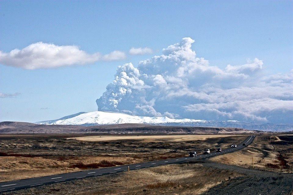
Volcano Details: Eyjafjallajökull is a composite (stratovolcano) covered by an ice cap. The name describes the volcano , with Eyja meaning island, fjalla meaning mountain, and jokull meaning glacier. You can find out how to pronounce Eyjafjallajokull on the BBC website .
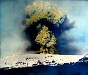
Its eruption can cause significant ash plumes and glacial meltwater floods known as “jökulhlaups.”
What caused the eruption of Eyjafjallajökull?
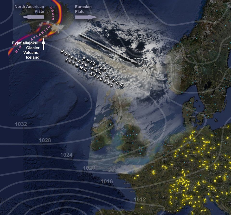
Iceland is situated on the Mid-Atlantic Ridge, a constructive plate boundary that divides the North American Plate from the Eurasian Plate. These two tectonic plates gradually drift apart because of the ridge push exerted along the Mid-Atlantic Ridge. As they move away from each other, magma from beneath the Earth’s crust fills the magma chambers located below Eyjafjallajökull. The interconnection of several of these chambers has created a substantial reservoir of magma beneath the volcano. Eyjafjallajökull is positioned underneath a glacier, adding to its complex structure.
What were the primary effects of the eruption of Eyjafjallajökull?
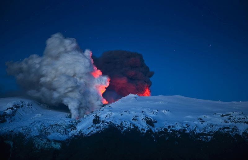
- Ash Cloud: The eruption created a massive ash cloud that turned day to night. The ash drifted over Europe.
- Air Travel Disruption: Over 100,000 flights were cancelled, affecting around 10 million travellers.
- Local Flooding: Melting glaciers caused flooding in the nearby areas.
- Damage to Agriculture : Ash fall led to the loss of grazing areas and contaminated water supplies.
- Property and roads: Homes and roads were damaged.
What were the secondary effects of the eruption of Eyjafjallajökull?
- Economic Impact : The airline industry alone lost £130 million a day due to airspace closure, totalling an estimated $1.7 billion. The price of shares in major airlines dropped between 2.5-3.3% during the eruption. Other sectors, such as tourism and farming, were also significantly affected.
- Environmental Impact : Long-term effects on soil and water quality were observed. Local water supplies were contaminated with fluoride.
- Health Concerns: Respiratory issues were reported due to fine ash particles in the air.
- Impacts on Kenya: The impact was felt as far afield as Kenya, where farmers laid off 5000 workers after flowers and vegetables rotted at airports. Kenya’s flower council says the country lost $1.3m daily in lost shipments to Europe.
What were the immediate responses to the eruption of Eyjafjallajökull?
- Evacuation : Around 800 people were evacuated from the immediate vicinity.
- Airspace Closure: European airspace was closed for several days.
- Emergency Services: Immediate response from local authorities, firefighters, and rescue teams.
What were the long-term responses to the eruption of Eyjafjallajökull?
- Monitoring and Research: Improved monitoring systems and research into ash cloud movement.
- Economic Support: Financial assistance for affected farmers and businesses.
- Regulations: Improved regulations for air travel during volcanic ash events.
- Airspace: The European Union developed an integrated structure for air traffic management. As a result, nine Functional Airspace Blocks (FABs) will replace the existing 27 areas. This means following a volcanic eruption in the future, areas of air space may be closed, reducing the risk of closing all European air space.
What opportunities did the eruption of Eyjafjallajökull bring?
Despite the challenges brought about by the eruption of Eyjafjallajökull, several benefits emerged from the event. One of the positive impacts was the environmental saving; the grounding of European flights during the eruption prevented the release of approximately 2.8 million tonnes of carbon dioxide into the atmosphere, as the Environmental Transport Association noted.
Additionally, the disruption in air travel led to a boon for other modes of transportation. Eurostar, for instance, experienced a significant increase in passenger numbers. The company recorded nearly a third rise in travel, accommodating 50,000 extra passengers on trains during this period.
Furthermore, the volcanic ash from Eyjafjallajökull deposited dissolved iron into the North Atlantic Ocean. This led to a plankton bloom, enhancing biological productivity in the region.
In response to the eruption’s negative publicity, the Icelandic government initiated a campaign to bolster tourism. The “Inspired by Iceland” initiative was launched with the specific goal of showcasing the nation’s scenic beauty, the warmth of its people, and the reassurance that Iceland was ready to welcome visitors. Consequently, the campaign had a positive effect, as evidenced by a substantial increase in tourist numbers, as depicted in the graph below.

Foreign visitor arrivals to Iceland
How does Iceland prepare for volcanic eruptions, and what was its impact?
Iceland has an effective monitoring system for its active volcanoes, with seismic stations and other instruments. There is close cooperation between meteorological, geological, and civil protection authorities. Public education and emergency planning are also vital to Iceland’s preparation strategy.
Iceland’s preparedness and rapid response, such as evacuating the area close to the volcano, mitigated the local impact of the eruption. However, the unprecedented disruption to air travel highlighted the need for better international coordination and understanding of volcanic ash’s effects on aviation.
The eruption of Eyjafjallajökull in 2010 is a crucial example of how a volcanic event can have local and global impacts. The incident underscored the importance of preparedness, monitoring, and international cooperation in minimizing the effects of such natural disasters. It also highlighted the interconnectedness of our modern world and how a geological event in one country can have far-reaching consequences.
Location and Eruption Details
Eyjafjallajökull erupted in 2010 in southern Iceland; it’s a stratovolcano covered by an ice cap. The eruption was caused by the North American Plate drifting from the Eurasian Plate along the Mid-Atlantic Ridge, creating a magma reservoir beneath the volcano.
Primary Effects
The eruption led to a massive ash cloud, air travel disruption with over 100,000 flights cancelled, local flooding from melting glaciers, and damage to agriculture , homes, and roads.
Secondary Effects
Economic loss reached an estimated $1.7 billion in the airline industry, long-term environmental impacts, health concerns from ash particles, and far-reaching effects on other countries like Kenya.
Immediate Responses
Approximately 800 people were evacuated; European airspace was closed for several days; emergency services responded quickly.
Long-Term Responses and Opportunities
Improved monitoring, regulations, and economic support were implemented; benefits included reduced CO2 emissions, increased passenger numbers in trains like Eurostar, enhanced biological productivity in the North Atlantic, and a successful Icelandic tourism campaign.
Preparedness and Impact
Iceland’s effective monitoring, public education, and emergency planning mitigated the local impact but emphasized the need for international coordination and understanding of volcanic ash’s effects on aviation. The eruption illustrated the interconnectedness of modern society and the far-reaching consequences of geological events.
Check Your Knowledge
Coming soon
Test Yourself
The natural environment, share this:.
- Click to share on Twitter (Opens in new window)
- Click to share on Facebook (Opens in new window)
- Click to share on Pinterest (Opens in new window)
- Click to email a link to a friend (Opens in new window)
- Click to share on WhatsApp (Opens in new window)
- Click to print (Opens in new window)
Please Support Internet Geography
If you've found the resources on this site useful please consider making a secure donation via PayPal to support the development of the site. The site is self-funded and your support is really appreciated.
Search Internet Geography
Top posts and pages.
Latest Blog Entries
Pin It on Pinterest
- Click to share
- Print Friendly
Search our site

Eyjafjallajökull 2010: How Icelandic volcano eruption closed European skies
Ten years ago the Icelandic volcano Eyjafjallajökul erupted, sending a plume of volcanic ash over nine kilometers into the sky.
The eruption was relatively small but its impact was massive. Europe experienced air travel chaos for almost one month as much of the continent ground to a standstill.
Eyjafjallajökul’s eruption remains one of the most memorable events of the twenty-first century and is also one of the defining moments for our aircraft research team, who played a key role in reopening European air space.
The Eyjafjallajökul eruption
The ice-capped volcano started to erupt in mid-March, following several months of increased seismic activity in Iceland.
The first eruptions were isolated on the North-East flank, but problems started to arise in April when the eruptions spread to the centre of the volcano, a three kilometer-wide crater surrounded by ice.
As the ice started to melt, glacial water began flooding into the volcano where it met the bubbling magma at the centre of the eruptions. This rapid cooling caused the magma to shear into fine, jagged ash particles.
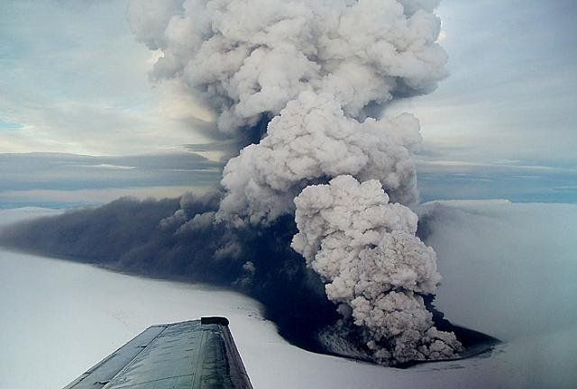
Large plumes of volcanic ash quickly spread above the volcano, moving eastwards with the jetstream towards the Faroe Islands, Norway, and northern Scotland.
Iceland responded by declaring a state of emergency and European airspace was closed as a safety precaution. It is estimated that airlines lost an estimated £130m every day that airspace remained closed, while millions of passengers were left stranded.
In order to reopen air space and reduce the economic impacts and disruption to travellers, the National Centre for Atmospheric Science was called in to map the volcanic plume.
Mapping the plume from the air and the ground
The ash plume contained large amounts of microscopic particles of hard volcanic rock , which can cause serious damage to any aircraft flying through.
Scientists from the National Centre for Atmospheric Science worked closely with the Civil Aviation Authority and the Met Office to track the plume and its contents using scientific instruments fitted to two research aircraft, alongside a series of computer models.
The FAAM Airborne Laboratory’s research aircraft was fitted with a special instrument that uses a laser to illuminate the ash particles from above. Another aircraft, a Dornier, flew below the plume to help map the ash.
The two aircraft were able to fly where commercial airlines could not, due to their ability to detect the volcanic plume via the research instruments on board.
To sample different layers of the plume, the aircraft flew up and down at heights between two and six kilometers. Meanwhile, scientists on the ground used computer models to build a picture of how the plume was moving.
“We used the NOAA HYSPLIT model to track the dispersion of the volcanic plume.” says Professor Stephen Mobbs, Executive Director of the National Centre for Atmospheric Science.
“This model tracks the trajectories of atmospheric pollutants from sources, using the observed wind fields as interpreted by global weather forecasting models.”
Dangers of volcanic ash to aircraft
Our response to the environmental emergency was pivotal in enabling passenger aircraft to return safely to the skies.
The volcanic ash was electrically conductive which meant it could cause thunder and lightning, or St Elmo’s Fire – an effect where metal parts of an aircraft start to glow. The airspeed indicator – which is essential for safe flight – can also be adversely affected making control of the aircraft very difficult. Dust is also likely to enter the aircraft, causing sulphurous smells and haze. Professor Guy Gratton, Cranfield University
Professor Guy Gratton, Associate Professor in Aviation and the Environment at Cranfield University, says that volcanic ash could cause plane engines to seize:
“As they touch the aircraft, and particularly the engines, the hard rock particles can wear away the skin of an aircraft, its windscreens, and engine components. At the high temperatures inside a jet engine the particles can potentially block fuel nozzles or even melt and then solidify in other parts of the engine causing mishandling or engine stoppage.”
Future environmental emergencies
After the Eyjafjallajökul eruption, Professor Stephen Mobbs and Dr Susan Loughlin, Head of Volcanology at the British Geological Survey, were appointed to advisory groups set up by the UK government to respond to similar environmental emergencies in future.
Researchers continue to watch Iceland’s volcanoes, and have since returned on a mission to monitor gases – including carbon dioxide and sulphur dioxide – over the potentially most active volcanoes.
Recently, there have been peaks in these warning gases, which can indicate an eruption is on the way. There are several large volcanoes in Iceland, and when they erupt they are likely to have considerable effects across western Europe and beyond. One is Katla, which last erupted in 1918 and is widely considered to be overdue for an eruption.
25 responses to “ Eyjafjallajökull 2010: How Icelandic volcano eruption closed European skies ”
- Pingback: South-West Iceland's Been Hit via 17,000 Earthquakes This Week. It May Be About to Erupt - Inspired Girls News Magazine
- Pingback: Esta semana, o sudoeste da Islândia foi atingido por 17.000 terremotos. Pode estar prestes a explodir | Blog Ambiental
- Pingback: South-West Iceland's Been Hit by 17,000 Earthquakes This Week. It May Be About to Erupt - PKNews10
- Pingback: South-West Iceland's Been Hit by 17,000 Earthquakes This Week. It May Be About to Erupt - Digi Flash
- Pingback: South-West Iceland's Been Hit by 17,000 Earthquakes This Week. It May Be About to Erupt - a news room
- Pingback: South-West Iceland's Been Hit by 17,000 Earthquakes This Week. It May Be About to Erupt - extension 13
- Pingback: South-West Iceland's Been Hit by 17,000 Earthquakes This Week. It Might Be About to Erupt | The Worldzz News
- Pingback: South-West Iceland's Been Hit by 17,000 Earthquakes This Week. It May Be About to Erupt - Science Global News
- Pingback: South-West Iceland’s Been Hit by 17,000 Earthquakes This Week. It Might Be About to Erupt – The News Point
- Pingback: South-West Iceland's Been Hit by 17,000 Earthquakes This Week. It May Be About to Erupt »
- Pingback: South-West Iceland’s Been Hit by 17,000 Earthquakes This Week. It May Be About to Erupt – bitarafhaber.net
- Pingback: South-West Iceland's Been Hit by 17,000 Earthquakes This Week. It May Be About to Erupt - Science Daily Press
- Pingback: South-west Iceland is shaking – and may be about to erupt | us19.co.in
- Pingback: South-West Iceland's Been Hit by 17,000 Earthquakes This Week. It May Be About to Erupt - Xnn News Blog
- Pingback: South-West Iceland's Been Hit by 17,000 Earthquakes This Week. It Might Be About to Erupt | Vale News
- Pingback: Sudoeste da Islândia foi atingido por 17.000 terremotos esta semana e vulcão pode estar prestes a entrar em erupção – CLM Brasil
- Pingback: Southwest Iceland is shaking – and may be about to erupt - Physics Everywhere
- Pingback: Southwest Iceland is shaking – and may be about to erupt · Enzyme Time
- Pingback: South-West Iceland's Been Hit by 17,000 Earthquakes This Week. It May Be About to Erupt - Newstimepaper
- Pingback: This week 17,000 earthquakes struck southwestern Iceland. It can be about Arop | World News, today's news, latest news
- Pingback: South-west Iceland is shaking and may be about to erupt - WeJan
- Pingback: South-west Iceland is shaking and may be about to erupt | My Adivasi
- Pingback: South-West Iceland's Been Hit by 17,000 Earthquakes This Week. It May Be About to Erupt - Tech and Science Post
- Pingback: Iceland is having its own Meghan and Harry - it is about to erupt - Brighton Journal
- Pingback: Southwest Iceland Is Shaking - Atlas Obscura
- Effects on Aircraft
- Signs of an Encounter
- Actions for Flight Crew
- Global Mitigation
- Eyjafjallajökull Impact
- Resources & References
The 2010 eruption of Iceland's Eyjafjallajökull volcano had a huge impact on air travel, changing the assessment of risk by the aviation sector and catalyzing new lines of scientific investigation. Ash advisories derived from dispersion-model output were issued by the London VAAC, depicting the presence of ash over large parts of Europe and the North Atlantic. Based on those advisories, over 300 airports in about two dozen countries, and a correspondingly large airspace, were closed in Europe during 15-21 April 2010. This resulted in massive impacts on air travel worldwide. Over 100,000 flights were cancelled over that week, affecting 7 million passengers, and resulting in $1.7 billion USD in lost revenue to airlines according to an analysis by Oxford Economics.
To reopen airspace, European aviation authorities endorsed the creation of a new type of concentration chart advisory product that delineated hazard zones based on dispersion model output of ash concentrations. So called 'low' ash concentrations were deemed to be defined as 3 . The concentration charts were adopted by air traffic management and airlines with the expectation that zones of low density ash could be transited with no or minimal risk of immediate aircraft damage providing a regime of enhanced risk assessment by airlines, including more frequent aircraft inspections, was adopted. Currently, concentration charts have only been adopted for operational use in Europe and the North Atlantic region, as outlined in Volcanic Ash Contingency Plan EUR and NAT Regions . The scientific validity and operational utility of the ash concentration charts have been questioned by international experts and therefore have not been implemented outside Europe.
Also in response to Eyjafjallajökull's impact on air travel, ICAO formed the International Volcanic Ash Task Force (IVATF) in May 2010, charging it to examine how best to define hazardous airspace and manage aviation risk. The IVATF included representatives from government and industry groups involved in aviation regulation, operations, and scientific investigations. The IVATF finished its work in June 2012, and a record of its results is available.
On the scientific front, there has been a notable increase in volcanic-cloud research since Eyjafjallajökull and the Cordon Caulle long-lived ash plume of 2011. A burst of scientific articles has been published, including in special journal issues (Hasager et al, 2010; Langmann et al., 2012). Overall, these eruptions have prompted the aviation industry, regulators, and scientists to work more closely together to improve the manner in which hazardous airspace is defined, forecast, and communicated.

Eyjafjallajokull 2010 volcanic eruption case study
Tectonic Hazards Community Insight
Provided in partnership with
![size_566_x_340[566x340]-rid_62b48434-b0f2-4099-a59a-bf1e89045d41](https://timeforgeography.co.uk/media/images/size_566_x_340566x340-rid_62b.2e16d0ba.fill-566x340-c100.png "iceland 2010 volcano case study")
IGCSE Geography Success Masterclass
Book now to be inspired and boost your grade!
Log in or sign up to manage your videos and for new video alerts Log in Sign up
Course links: GCSE • IGCSE • A-level • IA-level • IB Geography
This award-winning geography case study video resource reflects on the eruption of Eyjafjallajokull in 2010 and looks ahead to potential volcanic eruptions in Iceland.
In this video, we cover:
- The causes and impacts of the eruption, with visits to some of the localities directly affected - Volcano monitoring and preparedness - The impacts associated with the future eruption of Katla - Positive impacts of the volcanic eruption on tourism in Iceland
This teaching resource uses narrative, incisive interviews of local people, stunning archive footage of the eruption itself and supportive maps and diagrams to show that, through detailed scientific knowledge and monitoring, the people in Iceland not only understand the threats posed by volcanic eruptions but also see the rich benefits of living in the ‘Land of Fire and Ice’.
Visit Discover the World Education to download the free teaching resources, which accompany this video: http://bit.ly/2xzJ8r5
VELKOMIN Í KRAUMA
Krauma er staðsett hjá Deildartunguhver, skammt frá Reykholti.
Krauma er í 97 kílómetra fjarlægð frá Reykjavík.
Komdu við í Krauma og upplifðu sjarma Vesturlands.

Everything You Need To Know About The 2010 Eyjafjallajökull Eruption in Iceland
By Michael Chapman
What caused Iceland’s Eyjafjallajökull volcano to erupt in 2010, and what were the consequences? Can Iceland expect more volcanic eruptions in the future? Where can you learn more about these fascinating geological forces? Read on to find out all there is to know about the 2010 Eyjafjallajökull eruption in Iceland.
Why do they call Iceland the Land of Ice and Fire ?
Iceland erupts! Photo: LAVAcentre
Colloquially known as the land of ice and fire, Iceland is a volcanic island located in the North-Atlantic ocean.
Its nickname originates from the many volcanoes, geothermal springs and glaciers found dotted across the country.
These features have long added to Iceland’s reputation as a land of beauty and staggering natural contrasts—made all the more noticeable by such cosmic phenomena as the Midnight Sun and Northern Lights .
Sat atop a powerful underwater magma plume, it is one of the youngest landmasses on Earth—having first raised above ocean level 18 million years ago—and straddles both the North American and Eurasian tectonic plates.
These tectonic plates stand exposed in the UNESCO World Heritage Site, Þingvellir National Park—one of the three attractions that makes up Iceland’s popular Golden Circle sightseeing route.
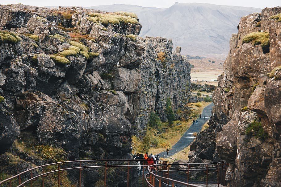
Visitors walk beside the North American tectonic plate at Þingvellir. Photo: WallpaperFlare.
You can also experience this continental divide on the Reykjanes Peninsula, a region closeby to Iceland’s capital, Reykjavík.
To this day, the country is still deeply affected by this unique geography.
Only in June 2020, North Iceland has experienced over 4.000 earthquakes , which hopefully provides some insight into the significant effect these primordial forces still have.
Of all the events that come to define Iceland moving into the 21st century, the 2010 eruption of Eyjafjallajökull was one of the biggest.
Together, let’s break down all there is to know about this most significant of volcanic incidents.
What is Eyjafjallajökull?
Eyjafjallajökull is one of the many stratovolcanoes found across Iceland. It stands an incredible 1651 metres tall, with a caldera that measures 3–4 kilometres in diameter.
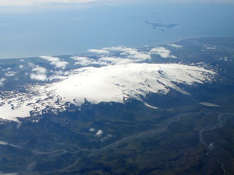
An aerial photograph of Eyjafjallajökull in full. Photo: Wikimedia. CC. TommyBee.
In short, it is a true giant of the landscape; one more than worthy of your time exploring deeper.
Other examples of Icelandic stratovolcanoes include Snæfellsjökull ( the Snæfellsnes Peninsula ) and Hekla in South Iceland .
‘ Jökull ’ is the Icelandic word for glacier, which is why you will see these letters cropping up again and again when discussing various frozen attractions in Iceland.
In full, Eyjafjallajökull translates to ' island mountain glacie r'.
Despites its enormous role in Iceland’s history, Eyjafjallajökull is one of the smaller ice caps found in the country.
The ice sheet that covers Eyjafjallajökull is approximately 100 square kilometres (39 sq mi) in size, thus feeding into countless outlet glaciers, including Gígjökull and Steinholtsjökull.
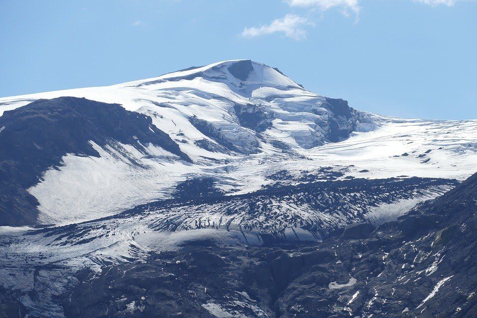
Eyjafjallajökull during more peaceful times. Photo: Pixabay.
Many tourists are a little confused as to how such concentrated heat could exist beneath a dense layer of ice. (Indeed, it does seem to spit in the face of common sense...)
However, the scientific evidence explains why this occurs. Glaciers are leftover remnants from the last Ice Age, which began around 1.6 million years ago. During this period, huge ice sheets covered most of the earth, shielding entire mountainscapes and valleys beneath them.
Dormant volcanoes do not emit the same level of heat as those that are still active, meaning that the glaciers remain cool enough to remain solid throughout the year.
Given their density, size and high-altitude, paired with annual seasonal changes, glaciers are a permanent fixture of Iceland’s landscape (—though, it should be added, they do face the threat of extinction due to an ever-warming climate.)
Some of our glaciers are even home to the seasonally fluctuating, yet beautiful, Iceland ice caves . These are frequently at the top of many travellers list - they are only accessible through Iceland ice cave tours .
As opposed to snow, the ice crystals that compose glaciers are generally much larger—often reaching the size of baseballs. This means glaciers melt much slower than one might expect, with the thawing process left unfinished by the time the winter rolls back around.
When geological heating does occur, glaciers are capable of thawing extremely rapidly. This causes floods of meltwater, known as Jökulhlaup, which can have devastating effects on the nearby area.
Other names for this phenomena include glaciovolcanos , or subglacial volcanoes .
Where is Eyjafjallajökull?
Eyjafjallajökull is located in South East Iceland. It is found north of the small village, Skógar, and west of the glacier, Mýrdalsjökull.
Shielded by glacial ice, guests can witness this gargantuan feature while travelling on the Ring Road —the only road which circles the entire country.
The best option for exploring the region surrounding Eyjafjallajökull is by either taking a fantastic Iceland self-drive tour or joining one of the many excellent Iceland South Coast tours .
The stratovolcano can be found at the exact coordinates, 63°37′12″N 19°36′48″W.
How did Eyjafjallajökull erupt?
Eyjafjallajökull at the beginning of the eruption. Photo: Flickr. Bjarki Sigursveinsson.
On the 26th February 2010, the Meteorological Institute of Iceland was forced to deal with a peculiar anomaly in their numbers. According to their readings, unusual seismic activity was noted alongside a rapid expansion in the earth’s crust.
This was evidence that underground magma had begun pouring into the chamber of Eyjafjallajökull volcano.
It should be noted that as far as volcanic eruptions go, Eyjafjallajökull’s was considered fairly small.
The eruption of Eyjafjallajökull volcano began with another eruption on the 20th March 2010. In the days previously, scientists had observed over 3.000 earthquakes near the volcano’s epicentre, roughly 7–10 kilometres deep into the earth.
The eruption did not first take place at Eyjafjallajökull’s highest peak—as one might naturally expect—but 8 kilometres east, in an area known as Fimmvörðuháls.
This region marks the boundary line between Eyjafjallajökull and Mýrdalsjökull. The eruption first broke the surface directly atop a popular hiking route in the area, and was expected by those scientists observing the events.
The initial eruptions at Fimmvörðuháls. Photo: LAVAcentre
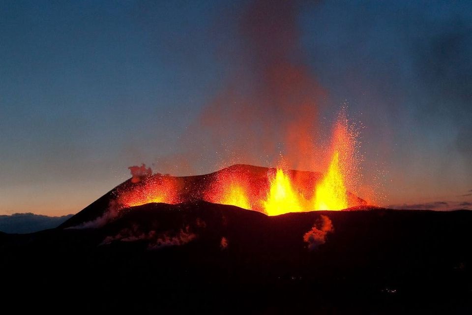
The Fimmvörðuháls eruption was a lava eruption, where molten magma flowed from an opening in the earth. It created a 200 metre high lava-fall, the tallest one ever measured.
The official end to the Fimmvörðuháls eruption was on 13th of April, 2010. But Eyjafjallajökull volcano wasn’t quite finished.
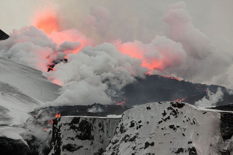
After a short intermission, the volcano began erupting once more on the 14th April 2010, this time from the top crater. This secondary event was far more dramatic than its predecessor—approximately 20 times as large as the Fimmvörðuháls eruption.
This second eruption was responsible for an ash cloud that reached several kilometres in the air, as well as substantial outburst flooding. This excess meltwater ( Jökulhlaup ) forced 800 nearby residents to evacuate the area.
The London-based Volcanic Ash Advisory Centre claimed the volcano had stopped erupting by the 21st May 2010. Even so, earthquakes at the epicentre continued to be monitored on a daily basis.
In August, the volcano was officially declared dormant, meaning the eruption lasted approximately five months.
What was the impact in Iceland?
One clear consequence of the eruption was that it reminded Icelanders as to the unbridled power forever bubbling beneath their feet.
Having violently disrupted the general tranquility Icelanders were so accustomed to, this cataclysmic reintroduction no doubt recalled distant cultural memories of former eruptions.
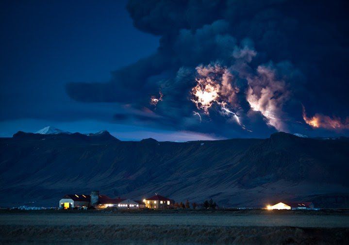
The second fissure ejecting fire! Photo: Wikimedia. CC. Boaworm
This includes the likes of the Laki Eruption of 1783—an event so impactful that many historians claim it was partly responsible for the French Revolution.
During the eruption, over 140 milljónum cubic metres of ash spread over the country, reaching the capital, Reykjavík and even further West to Keflavík Airport.
Two fresh craters were created due to the eruption. These were named Móði and Magni, after the sons of Thor, the Norse God of Thunder.
To commemorate the eruption, the Icelandic post office released three distinctive stamps, each containing actual ash that had fallen on the 17th April 2010.
Lighting with Eyjafjallajökull’s eruption. Photo: Ragnar Th. Sigurdsson. Arctic-Images
The Icelandic photographer Ragnar Th. Sigurdsson gained international recognition thanks to his captivating stills of the eruption in progress.
He took over 10,000 photographs of the event, with some of the most compelling taken during helicopter rides directly over the eruption itself. Many of these images were released in a best-selling book titled ‘Eyjafjallajokull: Untamed Nature.’
What was the impact in Europe?
Eyjafjallajökull’s 2010 eruption received significant media coverage around the world.
Aside from showcasing Iceland’s staggering, otherworldly nature, this had the rather amusing consequence of news anchors struggling to pronounce the glacier’s admittedly difficult name.
Of course, the impact was, in many ways, no laughing matter. The enormous cloud of ash ejected due to Eyjafjallajökull’s eruption severely hampered European air travel, stranding thousands of put-out passengers.
A map showing Eyjafjallajökull’s ash cloud over Europe. Photo: Flickr. Dominic Alves.
Interestingly enough, many social commentators have claimed that the media exposure the eruption brought upon Iceland is one of the leading factors that contributed to its tourism boom.
Some have even gone as far to say the eruption directly helped bring Iceland out of its economic recession.
Which volcanoes could predict in the near-future?
The prospect that Iceland will experience more volcanic eruptions in the coming years is not a possibility, but an absolute certainty.
There are four volcanoes that have long required a watchful eye.
Hekla is the first of these. The stratovolcano has erupted over 23 times in the last 1000 years, 4 of those happened in the last century.
In the Middle Ages, Hekla was commonly referred to as ‘ The Gateway to Hell ’—a testament to its lingering infamy and explosive nature.
Anyone who has ever seen footage of, or lava up close, is all too aware how this molten rock can shape itself into appearing like demons and devils desperate to escape to the overworld.
In other words, it’s not difficult to understand why our scientifically illiterate predecessors must have considered terrifying in a biblical sense.
The volcano, Katla, is another of Iceland’s mountains likely to erupt in the coming years.
Only 25 kilometres west of Eyjafjallajökull, Katla is a large volcano and incredibly active, with large-scale eruptions having taken place regularly between 930 CE and 1918 CE.
Historically, eruptions at Katla have occurred with an interlude of 20 - 90 years between them. It has been 103 since the last documented eruption, meaning one is overdue—a fact that Icelanders are all too aware of.
With that said, the area around Katla is one of South Iceland’s biggest attractions, especially its stunning ice caves, available to visit throughout the year - a tour of Katla ice cave should be on every travellers lists!
Katla erupted in 1918. Photo: Wikimedia. CC. RicHard-59.
Katla is one the largest providers of carbon dioxide (CO2) in the world, constituting up to 4% of the world’s total emissions.
Þorbjörn is a free-standing volcano located on the Reykjanes Peninsula, just north of Grindavík town, near the Blue Lagoon. In January 2020, an unusually large magma-build up (‘inflation’) was observed inside the Þorbjörn volcano, expanding roughly 3-4 mm per day.
It should be noted that there is no immediate concern an eruption will take place. The last to occur in the region took place in 1210-1240 CE, in a period known as ‘The Reykjanes Fires.’
Grímsvötn volcano can be found in the beautiful Vatnajökull National Park, best known for the nature reserve, Skafatfell, and the ‘Crown Jewel of Iceland’, Jökulsárlón glacier lagoon.
The peak of Grímsvötn measures at 1725 m (5,659 ft). It has the highest eruption frequency of any volcano in Iceland. It last erupted in 1998, 2004 and 2011, the last of which saw an ash plume of 12 kilometres in height.
Recently, Grímsvötn began showing signs that an eruption may soon occur. Scientists have recorded more seismic activity and increased geothermal heat than usual, and they believe that an eruption will likely happen in the next weeks or months.
Grímsvötn is located in the Icelandic Highlands, far enough away from inhabited areas to cause great damage. However, ash from eruptions is always a worry as the world learnt in 2010.
An aerial photo of Grímsvötn erupting. Photo: Grímsvötn Volcano Iceland
It is difficult to predict the consequences of how future eruptions might affect modern-day Iceland, given that it is largely dependent on the size of the explosion and their proximity to densely populated areas.
From a geological perspective, Iceland is one of the most fascinating countries to monitor, observe and explore. With an abundance of powerfully active volcanoes, it’s become part of the way of life for those residing in Iceland to be aware of the chances of the next eruption.
Though Iceland’s volcanoes since 2010 have earned a position on the centre stage of international news coverage, there has been a regularly explosive past from these geological giants all around the country for millennia.
As much as a visit to the land of fire and ice can include everything from Iceland Whale watching tours to a glacier expedition , or simply to hunt the Northern Lights from Reykjavik , you should always be aware of the incredible power that rumbles beneath your feet.
Come and explore Iceland in 2021 to see the mighty Eyjafjallajökull and so much more for yourself.

Why a Boat Tour on Jökulsárlón Glacier Lagoon Needs to be on Your Bucket List

Why is Iceland Called the Land of Fire and Ice?

Why You Need to See the Northern Lights in West Iceland

All You Need to Know About Ok Glacier, the first Dead Glacier in Iceland

Best Things to See and Do in West Iceland

Everything You Need to Know About Deildartunguhver (and other Hot Springs) in Iceland

History of Geothermal Spas in Iceland
Staðsetning.
Krauma er staðsett hjá Deildartunguhver, skammt frá Reykholti.
Komdu við í Krauma og upplifðu sjarma Vesturlands.
HEIMILISFANG
Deildartunguhver, 320 reykholt, 64.6644782 -21.41228, [email protected].
SÍMI
+354 5556066
SAMFÉLAGSMIÐLAR
Go tt aðgengi
Iceland volcano spews smoke, lava in 4th eruption since December
Nearby fishing town evacuated again as sky near reykjavik glows bright orange.

Iceland volcano erupts for 4th time since December
Social sharing.
A volcano in Iceland erupted for the fourth time since December on Saturday, the country's meteorological office said, spewing smoke and bright orange lava into the air in sharp contrast against the dark night sky.
In a video shot from a Coast Guard helicopter and shown on public broadcaster RUV, fountains of molten rock soared from a long fissure in the ground, and lava spread rapidly to each side.
The eruption began at 8:23 p.m. local time and the fissure was estimated to be about 2.9 kilometres long, roughly the same size as the last eruption in February, the Icelandic Meteorological Office said in a statement.
Authorities had warned for weeks that an eruption was imminent on the Reykjanes peninsula, just south of Iceland's capital, Reykjavik.
The site of the eruption was between Hagafell and Stora-Skogfell, the same area as the previous outbreak on Feb. 8, the Met Office said.
"This was definitely expected," said Rikke Pedersen, head of the Nordic Volcanological Centre.
"Of course the exact time of the eruption is impossible to predict. The first cues of this moving towards the surface actually only happened about 15 minutes in advance," she said.
- Analysis: Bob's blog What makes Iceland so volcanically active? Shifting plates below the island nation
The website for Reykjavik's Keflavik Airport showed it remained open both for departures and arrivals.
Lava appeared to be flowing rapidly south toward the nearby fishing town of Grindavik, where a few of the nearly 4,000 residents had returned following earlier outbreaks, the Met Office said.

The town was again being evacuated, public broadcaster RUV reported. An outbreak in January burned to the ground several of its homes.
"We're just like, this is business as usual," Kristin Maria Birgisdottir, who was evacuated from Grindavik in November, told Reuters.
"My son... just called me and said, 'Mamma, did you know the eruption has started?' And I was like, 'Yeah, I did know.'

"So it's like we don't even bother telling each other anymore."
Icelandic police said they had declared a state of emergency for the area and the Civil Defence authority dispatched a helicopter to survey the extent of the eruption.
The nearby Blue Lagoon luxury geothermal spa immediately shut its doors, as it did during previous eruptions .
Iceland boasts more than 30 active volcanoes, making the small, nordic island a prime destination for volcano tourism — a niche segment that attracts thousands of thrill seekers.
In 2010, ash clouds from eruptions at the Eyafjallajokull volcano in the south of Iceland spread over large parts of Europe, grounding some 100,000 flights and forcing hundreds of Icelanders to evacuate their homes.
Volcanic outbreaks in the Reykjanes peninsula are so-called fissure eruptions, which do not usually cause large explosions or significant dispersal of ash into the stratosphere.

#TheMoment a photographer captured a 'surreal' Icelandic volcano eruption
Gases from the eruption were traveling westwards out at sea, the meteorological office said.
Scientists fear the eruptions could continue for decades, and Icelandic authorities have started building dykes to divert burning lava flows away from homes and critical infrastructure.
- How a massive volcano helped to convert Iceland's pagans to Christianity
The February eruption cut off district heating to more than 20,000 people as lava flows destroyed roads and pipelines.
Iceland's seismic and volcanic activity is due to its location between the Eurasian and the North American tectonic plates, among the largest on the planet, which move in opposite directions.
Related Stories
- Feb 24: Icelanders reap the costs and benefits of living on a volcanic island and more…
- Iceland's famous Blue Lagoon evacuated as volcano erupts for 3rd time
- Houses in Iceland 'split apart' by tremors as volcanic eruption looms
The request to the URL needs to be verified.
The request to the URL is paused, and must be verified for you to access it. This question is for testing whether you are a human visitor, and to prevent automated spam submission.
What code is in the image submit
Incident ID: 14604593416194288840
For comments and questions: [email protected]
IMAGES
COMMENTS
Eyjafjallajokull is located below a glacier. The Eyjafjallajökull volcano erupted in 920, 1612 and again from 1821 to 1823 when it caused a glacial lake outburst flood (or jökulhlaup). It erupted three times in 2010—on 20 March, April-May, and June. The March event forced a brief evacuation of around 500 local people.
Case Study - The 2010 eruption of Eyjafjallajökull Background Information. Location: Eyjafjallajökull is located in southern Iceland. Level of Development in Iceland: Iceland is a developed country with a strong economy. It has advanced infrastructure, healthcare, education, and a high standard of living.
Eyjafjallajökull 2010: How Icelandic volcano eruption closed European skies. Ten years ago the Icelandic volcano Eyjafjallajökul erupted, sending a plume of volcanic ash over nine kilometers into the sky. The eruption was relatively small but its impact was massive. Europe experienced air travel chaos for almost one month as much of the ...
Between March and June 2010 a series of volcanic events at Eyjafjallajökull in Iceland caused enormous disruption to air travel across Western Europe . The disruptions started over an initial period of six days in April 2010. Additional localised disruption continued into May 2010, and eruptive activity persisted until June 2010.
Journal of Geophysical Research: Atmospheres. First Published: 27 January 2012. Key Points. A method for forecasting peak volcanic ash concentrations is described. Method validated using observations from the 2010 Eyjafjallajokull eruption. Uncertainties in modeled ash concentrations are numerous and large.
The eruption of Eyjafjallajökull Composite map of the volcanic ash cloud spanning 20 March 2010.. The eruption of the Eyjafjallajökull volcano in Iceland on 20 March 2010 affected the economic, political and cultural activities in Europe and across the world.. There was an extensive air travel disruption caused by the closure of airspace over many countries affecting the travel arrangements ...
Case Study Summary Sheet for Eyjafjallajökull Eruption 2010 (HIC) ... Eruption was declared officially over on 20th October 2010, six months after it started. ... potentially the most destructive volcano on Iceland. Iceland lies at the junction of two major plates. The North American and Eurasian plates are pulling away from one another and ...
Case study of the Eyjafjallajökull eruption in Iceland in 2010. This is the ninth video for the AQA GCSE 9-1 Geography course, and the ninth video of the Cha...
Aviation. The 2010 eruption of Iceland's Eyjafjallajökull volcano had a huge impact on air travel, changing the assessment of risk by the aviation sector and catalyzing new lines of scientific investigation. Ash advisories derived from dispersion-model output were issued by the London VAAC, depicting the presence of ash over large parts of ...
Eyjafjallajökull, Iceland - 2010 Type of Plate Boundary The volcano is situated on a constructive plate boundary between the North American and Eurasian plate . Eyjafjallajökull is a 500m long fissure volcano , that erupts basalt. Basaltic lava is fluid in nature. There is a glacier above the volcano. Hazards
This award-winning geography case study video resource reflects on the eruption of Eyjafjallajokull in 2010 and looks ahead to potential volcanic eruptions in Iceland. In this video, we cover: - The causes and impacts of the eruption, with visits to some of the localities directly affected. - Volcano monitoring and preparedness.
Everything you need to make the infamous 2010 eruption the ultimate "Thinking Like a Geographer" case study! 11 years ago, a small, unheard of, unpronounceable volcano erupted in the south of Iceland. Iceland, being on the Mid-Atlantic Ridge and on a magma hot spot, had experienced many eruptions before, and since - but this captured the ...
Volcanoes case study 1 - Eyjafjallajökull Tectonic setting of the hazard The nature of the hazard (type ... it has been less active than other volcanoes of Iceland's eastern volcanic zone, and relatively few Holocene lava flows are known. ... Before the eruption in 2010 the volcano is known to have erupted in 920, 1612, 1821 and 1823. ...
Volcano case studies presentation - Teacher's Notes ... Eyjafjallajökull 2010 eruption Eyjafjallajökull (ey-yah-fyal-lah-yo-kul) is a stratovolcano situated in southern Iceland. Like other volcanoes in Iceland, Eyjafjallajökull lies beneath an ice cap which is 200m thick and 100km2 in area. On 20 March 2010, following months of increased ...
Eyjafjallajökull eruption, Iceland 2010: Suggested Answers Describe the location 5 of the case study. Eyjafjallajökull is a small ice-cap in southern Iceland. The name means 'island mountain glacier'. Below the toxic gas emissions, etc. ice is a volcano. Iceland is in the Atlantic Ocean. Identify two primary impacts of the eruption.
Photo: LAVAcentre. The Fimmvörðuháls eruption was a lava eruption, where molten magma flowed from an opening in the earth. It created a 200 metre high lava-fall, the tallest one ever measured. The official end to the Fimmvörðuháls eruption was on 13th of April, 2010. But Eyjafjallajökull volcano wasn't quite finished.
Title: Eyjafjallajökull Eruption 2010 - Case Study - World at Risk - Edexcel Geography IAL Created Date: 20191125163824Z
Despite volcanic eruptions in earlier times, the eruption of Iceland's Eyjafjallajökull in April and May 2010 served as a climactic point in aviation history. Stakeholders in the air traffic industry were forced to reevaluate policies, safety standards, and guidelines and to seek new methods for data collection.
Early March to mid-April 2010. What is the GDP per capita of Iceland? $59,260 per capita (HIC) What were the physical causes of the eruption? Divergent plate boundary. Iceland is located on the North American plate (Moving West) and the Eurasian plate (Moving East) Mid-Atlantic ridge created. Plates are moving apart at a rate of 1-5 cm per year.
Eyjafjallajokull is located below a glacier. The Eyjafjallajökull volcano erupted in 920, 1612 and again from 1821 to 1823 when it caused a glacial lake outburst flood (or jökulhlaup). It erupted three times in 2010—on 20 March, April-May, and June. The March event forced a brief evacuation of around 500 local people.
In 2010, ash clouds from eruptions at the Eyafjallajokull volcano in the south of Iceland spread over large parts of Europe, grounding some 100,000 flights and forcing hundreds of Icelanders to ...
The volcano was covered by a glacier, and sub glacial activity where cauldrons melted causing floods of meltwater on 14th April. Travelled at 3 000 m^3/sec, causing the evacuation of 700 people. Hazards - lava. Emitted from a 500m long fissure at 1000°C, spewing 150m into the air. Mostly basaltic.
But the main reason behind Iceland's formation is what is known as a mantle plume, which lies directly under the island. It carries hot material from deep inside the Earth to the surface, where volcanoes are formed. "The boundary between the Earth's core and mantle is at a depth of 2,900 kilometres.
As the volcano sits under a glacier, the ice melted rapidly, causing glacial floods. This caused a major flood, prompting the evacuation of 700 people. Washed roads away. Primary effects of the Iceland eruption - Crops. Crops were destroyed by the falling ash. Secondary effects of the Iceland eruption - The effects that the eruption had globally.
Historical perspective Iceland's long history of volcanic activity has been documented since the settlement of the island in the 9th century. Notable eruptions, like the Laki eruption in 1783 and ...
VOLCANO CASE STUDY ICELAND 2010. Flashcards; Learn; Test; ... Get a hint. Social Impacts. Click the card to flip 👆. People living in rural areas "downwind" of the volcano had to wear goggles and facemasks as the ash was so thick/500 cattle farmers and family had to evacuate/Many roads near the volcano were shut down and were damaged after ...